![]()
by Erik Zuker, senior project engineer at HNTB; Craig Toth, group director at HNTB; and Ed Shappell, director of Trimble Digital Services
Increased data availability and powerful analytical techniques are enabling more resilient design solutions and proactive infrastructure management. With the emergence of more data generated than at any previous point in history, the transportation industry can leverage it to provide actionable insights like never before.
These datasets provide a more granular understanding of the demands on our roadways, their actual capacity and how the system experiences the impacts of external forces, allowing for more proactive maintenance strategies.
Assessing Pavement Conditions
For many agencies, it is critical to accurately plan and fund both bridge and roadway maintenance efficiently to minimize the impact for the road user. Access to a vast amount of data and data resources can increase an agency’s ability to quantify pavement conditions and assist with short and long-term planning.
New technologies, which include detailed freight data, high-quality weather metrics and LiDAR scans for an entire state, may be used to create data models that agencies can utilize for asset management and decision-making. Leveraging this data is critical to navigating this new environment.
Leveraging Enhanced Weather Data
While many transportation agencies already use detailed weather information to forecast near-term risk and plan post-event logistics, there are also significant applications of weather information that may support long-term planning and understanding damage at the asset level.
The National Oceanic and Atmospheric Administration (NOAA) has made significant investments in recent decades to collect and forecast a wide array of environmental factors. Because of advances in cloud computation and storage, it is possible to access and effectively analyze scenarios like never before. One program that allows cloud access to vast amounts of information is NOAA’s Open Data Dissemination (NODD) program. It provides public access to NOAA’s open data on commercial cloud platforms through public-private partnerships. With this expansive amount of data, it is crucial to have subject matter expertise to develop accurate climate scenarios.
A pavement’s service life is affected by numerous environmental factors, including temperature fluctuations, UV exposure and freeze-thaw cycles. Changes in soil saturation, estimated by precipitation metrics, have shown to reduce a pavement’s subgrade resilient modulus.
Because the datasets collected and maintained by NOAA are provided in a GIS-ready, location-based format, it is possible to filter down to the conditions experienced by an individual segment of roadway. Significant advances in machine learning now enable gathering insights from massive datasets that can be performed at scale. The investments made by NOAA to collect weather data are a perfect example of how datasets that already exist may be repurposed for other beneficial uses.
LiDAR Collection and Analysis at Scale
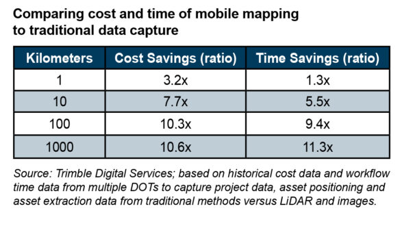
LiDAR surveys, which include pavement scans—supplemented with high-resolution photos and analyzed using artificial intelligence—can now be performed to provide quantitative metrics on pavement damage and wear with increased efficiency. The ability to perform these scans on a recurring basis allows damage analysis and projections at a scale and granularity that was not feasible even a few years ago. This may lead to a significant decrease in overall costs for hardware by leveraging mobile mapping, as compared to the cost and time required for traditional data capture.
At the same time, the industry has seen a similar increase in performance and accuracy of the data captured. There has never been a better time for DOTs to consider these new technologies and approaches to improve their asset life cycle management workflows. Advances in this technology—and the automated approaches to analysis they enable—may allow transportation agencies to do more frequent pavement evaluations at a lower cost, especially for areas of heavy truck traffic or adverse environmental conditions that experience accelerated damage.
The Takeaway
There is a growing movement across all portions of transportation systems to utilize data at scale and in turn gain meaningful insights. This increased data availability and analysis means that charting a path forward into an uncertain future can be navigated with more confidence.
These advances could not have come at a better time. With the funding available through the Infrastructure Investment and Jobs Act, there is a significant opportunity to apply new technology and innovative thinking to advance the efficiency and cost-effectiveness of the planning, design, and maintenance of public infrastructure.
Above photo credit: CalTrans Division of Construction and Division of Land Survey
Related News

2025 ARTBA Chair Jeff Nelson: Building from A to Z
by John Schneidawind, ARTBA vice president of public affairs Jeff Nelson, who was…

Celebrating a Century of Excellence: The Legacy of United Infrastructure Group
by Rett Triplett, P.E., UIG vice president of strategic partnerships, and Kaitlyn Triplett,…
A Century of Building the Extraordinary: Celebrating 100 Years of Zachry
by Beth McGinn, vice president of communications, ARTBA This year, San Antonio-based Zachry…